
Three (Cross) Dykes on Middle Hill – Kidland Forest Northumberland
Scheduled Monument List Entry Ref: 1007525
Grid Tile: NT81SE
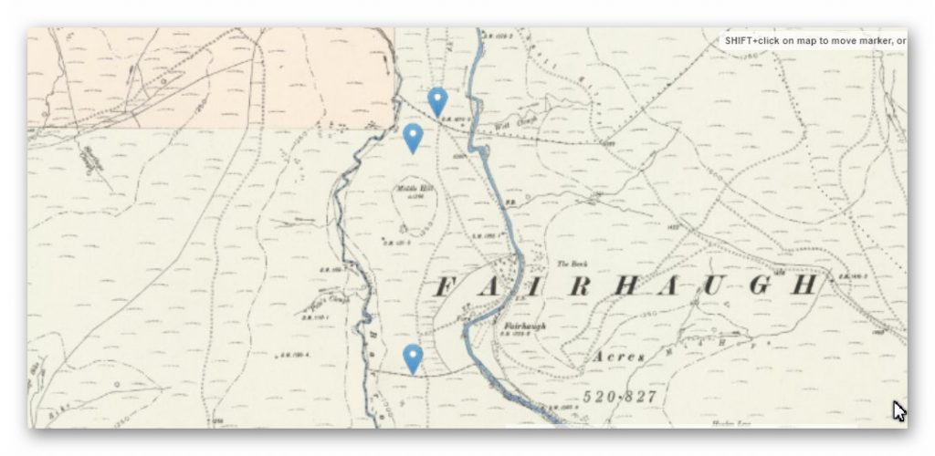
OS Map (1800s)
GE Satellite Map

LidAR Map

Dyke: NT87318 12052 (most northerly)
Length (m): 396
Orientation: W – E
Class Designation*:
Overall Width (m): 7
Ditch Width (m): 3
Bank Width (m): 4
Connectivity**: River
Ditch Shape: ?
Volume (cu.m): 1,544 (@ 1.3 depth)
Man hours to complete: 5,148
Estimated Construction Date: ?
Dyke: NT87321 12792 (middle)
Length (m): 154
Orientation: NW – SE
Class Designation*:
Overall Width (m): 6
Ditch Width (m): 3
Bank Width (m): 3
Connectivity**: River
Ditch Shape: ?
Volume (cu.m): 601 (@ 1.3 depth)
Man hours to complete: 2,003
Estimated Construction Date: ?
Dyke: NT87403 12912 (bottom)
Length (m): 162
Orientation: NW- SE
Class Designation*:
Overall Width (m): 11
Ditch Width (m): 6
Bank Width (m): 5
Connectivity**: River
Ditch Shape: ?
Volume (cu.m): 1,264 (@ 1.3 depth)
Man hours to complete: 4,212
Estimated Construction Date: ?
Dyke: NT87440 13004 (missing)
Length (m): 417
Orientation: N – S
Class Designation*:
Overall Width (m): 8
Ditch Width (m): 4
Bank Width (m): 4
Connectivity**: River
Ditch Shape: ?
Volume (cu.m): 2,168 (@ 1.3 depth)
Man hours to complete: 7,228
Estimated Construction Date: ?
Dyke: NT87388 12197 (missing)
Length (m): 1484
Orientation: N – S
Class Designation*:
Overall Width (m): 14
Ditch Width (m): 8
Bank Width (m): 6
Connectivity**: River
Ditch Shape: ?
Volume (cu.m): 15,433 (@ 1.3 depth)
Man hours to complete: 51,445
Estimated Construction Date: ?
Scheduled Monument Report:
The monument includes three cross dykes of prehistoric date situated on Middle Hill. It is divided into three separate areas.
The Barrow and Usway Burns define the east and western sides of Middle Hill, and two of the cross dykes have been carefully situated in order to utilize the topograpy of the hillside and demarcate the northern side of the hill from surrounding lower ground; the third cross dyke is situated at the southern end of Middle Hill. The latter is the best preserved of the dykes and runs east-west between the Barrow and the Usway Burns for 270m.
The substantial bank of earth is 6m wide and stands to a height of 2m. There is a ditch 2m wide on the northern side of the bank for most of its length; however 10m west of the plantation entrance the bank makes a slight change of angle and from here the ditch runs along the southern side of the bank.
The central dyke, situated at the northern end of the hill is visible for 170m running between the Barrow and the Usway Burns; its western end is best preserved where it takes the form of substantial double earthen banks with a medial ditch. However it is for the most part planted with trees and is visible as a single low bank standing to 1m high with a shallow ditch 2m wide to its north.
The most northerly ditch is rather different in character to the previous two dykes: it is on average 1m high and 2m wide with a shallow ditch to its north. It is rather sinuous in nature and has clearly been re-used as a medieval or post-medieval boundary wall. The three dykes demarcated an area of land, Middle Hill, and controlled access to it. They have continued in use as parish boundaries from the Middle Ages and today demarcate an area of forestry plantation. The fence line which dissects the most northerly dyke and that which runs along the southern dyke are excluded from the scheduling but the ground beneath them is included.
Comments:
Analysis shows that there maybe TWO Dykes missing from the Scheduled Monument report which are in a N-S direction across the high ground.
References:
https://historicengland.org.uk/listing/the-list/list-entry/1007525
http://prehistoric-britain.co.uk/gigantic-prehistoric-canals-dykes-wansdyke