Raised Beaches – that never meet the Sea
“Science is a way of thinking much more than it is a body of knowledge.” – Carl Sagan
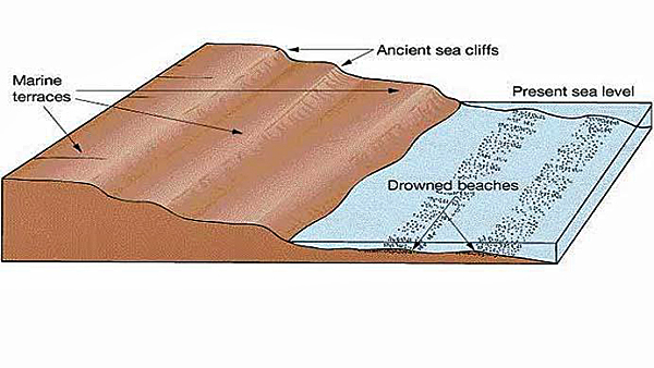
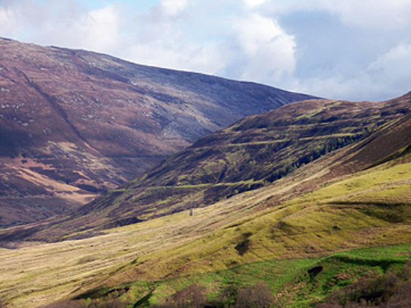
A raised beach, marine terrace, or perched coastline is an emergent coastal landform. Raised beaches and terraces are beaches or wave-cut platforms high above the current shoreline relative to a fall in the sea level. These are seen in Norway or Scotland, where the ice cap has compressed and sunk the ground surface layer (Isostatic Transformation) and has rebounded back to its original height for thousands of years.
One of these ‘Raised Beaches’ classic cases is on the South Coast of Britain between Bournemouth and Brighton. Unfortunately, an ice cap has never reached these areas during the last half a million years, although the raised beaches are just 18″ below the topsoil.
Theories of how this sandy layer that appears in the soil layers high in hill sediments are abundant, including British tsunamis (giant tidal waves that left sand deposits on hills).
If you consult Wikipedia, it will tell you:
The total displacement of the shoreline relative to the age of the associated interglacial stage allows calculation of a mean uplift rate or the calculation of eustatic level at a particular time if the uplift is known
In order to estimate vertical uplift, the eustatic position of the considered paleo sea levels relative to the present one must be known as precisely as possible.
Our chronology relies principally on relative dating based on geomorphologic criteria but in all cases, we associated the shoreline angle of the marine terraces with numerical ages. The best-represented terrace worldwide is the one correlated to the last interglacial maximum (MISS 5e) (Hearty and Kindler, 1995; Johnson and Libbey, 1997, Pedoja et al., 2006 a, b, c). Age of MISS 5e is arbitrarily fixed to range from 130 to 116 ka (Kukla et al., 2002) but is demonstrated to range from 134 to 113 ka in Hawaii and Barbados (Muhs et al., 2002) with a peak from 128 to 116 ka on tectonically stable coastlines (Muhs, 2002).
Older marine terraces well represented in worldwide sequences are those related to MIS 9 (~303-339 ka) and 11 (~362-423 ka) (Imbrie et al., 1984). Compilations show that sea level was 3 ± 3 meters higher during MISS 5e, MIS 9 and 11 than during the present one and –1 ± 1 m to the present one during MIS 7 (Hearty and Kindler, 1995, Zazo, 1999). Consequently, marine terraces are less pronounced and sometimes absent in MIS 7 (~180-240 ka; Imbrie et al., 1984) (Zazo, 1999). When the elevations of these terraces are higher than the uncertainties in paleoeustatic sea level mentioned for the Holocene and Late Pleistocene, these uncertainties have no effect on overall interpretation.
A sequence can also occur where the accumulation of ice sheets depressed the land so that when the ice sheets melt, the ground readjusts with time, thus raising the height of the beaches (glacial-isostatic rebound)and in places where co-seismic uplift occurs. In the latter case, the terraces are not correlated with sea level high stand even if co-seismic terraces are known only for the Holocene.
What is more interesting is the note Wikipedia has placed with this explanation, which states:
“This article may be too technical for most readers to understand. Please help improve this article to make it understandable to non-experts, without removing the technical details. The talk page may contain suggestions.” (September 2010)
And here lies the problem with this theory – it’s far too complicated to be true!
This is a much simpler explanation geologist’s use:
Raised beaches
• When sea levels fall, more of the coastline is revealed. Beaches, no longer combed by wave are left, stranded and exposed above the new sea level
• These features are called raised beaches
• The lower part will often show signs of marine erosion, and a small cliff may be formed
• Any former cliff-line is also left stranded. No longer undercut by the sea if it becomes a degraded cliff. Over time, it will often become clothed in shrubs and bushes – a sure sign of physical inactivity
Geologists have come up with this complex argument for a natural phenomenon because quite clearly, we see sandy soil levels in hills and other places where we perceive that water has not been for millions of years. However, in some countries, this geological problem can be easy dismissed as within the last 20,000 years (a relatively short and recent period in geological terms), these areas have had ice covering them from the last ice age, and the severe conditions that it produces is always a good excuse for such events.

These events include the rising and falling of continents (isostatic transformations); although closer examination of these events shows if they were causing these raised beaches, the effect was limited.
Geologists claim that raised beaches in Western Scotland have been recognised 8m, 15m and 30m above the present sea level, and raised beaches can only technically exist and be seen on coastal areas as the surface area below the beach has had to be cut away by the sea to reveal the raised beach.
The first problem with this theory is that these beaches are at different levels. If you look at a UK map today, you will notice all the beaches are at one level – sea level. So this is where ‘localised’ factors are introduced to the geological equation.
The sea in the past was lower than today, and at the end of the last ice age, it would have been some 60m lower – so these Scottish raised beaches are not 8m, 15m and 30m higher than sea level but 68m, 75m and 90m.
This is where the ‘isostatic transformation’ kicks in, or as Wikipedia explains it as:
Post-glacial rebound (sometimes called continental rebound, glacial isostasy, glacial isostatic adjustment) is the rise of land masses that were depressed by the huge weight of ice sheets during the last glacial period, through a process known as isostasy. It affects northern Europe (especially Scotland, Estonia, Fennoscandia, and northern Denmark), Siberia, Canada, the Great Lakes of Canada and the United States, the coastal region of the US state of Maine, parts of Patagonia, and Antarctica.
You instantly know when the academics are floundering for explanations when they use different words for the same effect -this is because when they get stuck using one explanation. They will tell you, “no that’s glacial isostasy” or “this is glacial isostatic adjustment” – something completely different.” Its a sure way of saying ‘no idea’ but if I make up a series of complex names with intelligible explanations – you will not ask me awkward questions and think I’m knowledgeable as I have a PhD and an academic title??
Politicians also use this well-known ploy to justify the millions of dead during the current covid crisis – who stated that they were just ‘following the science’ – people with PhD’s and grand titles who are never wrong??
For more information about British Prehistory and other articles/books, go to our BLOG WEBSITE for daily updates or our VIDEO CHANNEL for interactive media and documentaries. The TRILOGY of books that ‘changed history’ can be found with chapter extracts at DAWN OF THE LOST CIVILISATION, THE STONEHENGE ENIGMA and THE POST-GLACIAL FLOODING HYPOTHESIS. Other associated books are also available such as 13 THINGS THAT DON’T MAKE SENSE IN HISTORY and other ‘short’ budget priced books can be found on our AUTHOR SITE. For active discussion on the findings of the TRILOGY and recent LiDAR investigations that is published on our WEBSITE you can join our FACEBOOK GROUP.